NORTH FROM CARNARVON
If you look at a map you will
discover the trip from Carnarvon to Karratha to be a long and desolate one. We had a few roadside overnight stops
(together with about 10 other vans) and at the river on the first night we
experienced some beautiful sunset and sunrise reflections from the bridge
crossing the river. These made this
section of the trip worthwhile.
Travelling further north we once again experienced the lovely Pilbara
region and several close mine sites. We
had a comfort stop at the Fortescue River Roadhouse (one of 4 between Carnarvon
& Karratha) and were gob-smacked to see the accommodation quarters at the
back. You have to keep in mind that we
are in the middle of nowhere. We asked
the girls inside what they were for and were told “accommodation for the mine
up the road”. There was beds for 200
people there. Several kilometres on and
we spot the mine. It is impossible to
get your head around the number of mines in this part of WA. This country is straight from a western movie
scene (except that it is flat as a pancake).
They may as well mine the place, because it isn’t fit for anything else. Onward ever onward and we reach the Karratha
turnoff. Enquiries at the tourist info
centre reveal we need to go further in to get a van park as the one near there
is full of miners. This town is truly
being ruined by the mining thing. There
is soooooooooo much construction work happening they can’t keep pace. Accommodation here cost us $52 per night for
a powered site. Rents range from $800 to
$2000 per week for a house. OK if
you are earning big bucks at the mines and the mine companies are paying part
of the rent, but for locals doing everyday jobs, it is impossible and many have
left town. We made the van park our home
for three days while we explored the nearby areas. We did a daytrip to
Roebourne, Wickham, Pt. Samson and Cossack.
Roebourne is the oldest town in the North West of WA. Established in 1866 and has many fine
restored buildings of the time, many built before 1900. The Info Centre is the old Goal. It was build in the shape of a cross (a
miniature plan of Woodford goal) with the control centre in the middle and
cells running Nth, Sth, East & West from there. A lovely old building. Unfortunately, the town is very poorly looked
after and has a large Aboriginal population.
Wickham is a small town (about to explode in population) on the way to Pt Samson. Not much there at present, but is due for a
massive housing increase for the workers at the port. Pt. Samson is a quaint seaside spot and is
the port for ore loading from local mines. The town of Cossack is a ghost
town. Several old buildings have been
restored and the signage around the town for tourist is first class. You can self drive the town and learn about
the olden times. A very impressive place and there’s a lighthouse, which was built in 1888 and is
still intact, on an island 2kms offshore. We also spent some time at Dampier (this is where the famous "Red Dog" came from) - on the coast off Karratha. Rio Tinto has
a salt mine on the way to Dampier and for klms along the road all you can see
is salt pans. The ship loading of the
salt is at Dampier and it is also the port for loading iron ore from Tom Price
mine. It is quite a run-down town now
and has nothing going for it. At
Karratha, Woodside has their enormous North West Shelf Gas treatment
plant. It is huge. You can do a visit very close to it and when
we were there they were testing a new treatment works. The gas burnoff coming out of the chimney was
unbelievable. The noise was like a jet
engine. The day was so windy that the
flame was almost horizontal. This plant
takes the gas from wells offshore (some as far away as 180kl) and turns it into
liquid for transport mostly to China. By
turning gas to liquid form they can fit 600times more into a tanker. The old
part of this plant has been operating for 27 years. Karratha is set along the coastline with a
small range very close behind it. It is
on the natural tidal plains with absolutely no protection from onshore
winds. And windy it can get. The van parks have chain tiedown points on
every slab for cyclone anchorage. Wouldn’t want to be there in a cyclone
event. We left Karratha and headed south
to the Millstream-Chichester National Park.
We were told it was worth a look.
On arrival, we discovered we
could not open the tailgate of the Patrol. Hell!! Our spare water and ALL
our recovery gear is in there, behind the cargo barrier.
This is where the headwaters
of the Fortescue River are and the natural aquifer supplies water to
Karratha. One can only hope that they
don’t destroy the delicate balance here by taking too much water from the
aquifer in the future. The volume of water passing through here at times, must
be incredible. Had a look around, and decided to leave next day. We got back to the Tom Price road (dirt all
the way) and the sensor on our tyres let us know that we had a slow leak in the
passenger side of the van. Murphy’s law
always takes over, doesn’t it! Couldn’t
get to the wheel brace, jack or compressor.
Got help from a couple of young fellows passing who changed our tyre and
we were off again. We had about 100klm
dirt to go. We tossed up whether to go back to Karratha or take the road which
would lead to another spot (Python Pool) which we wanted to see on the way to
the Port Headland road. Decided to go to
Python Pool. It could be lovely, at
times. But it was all green and not nice so off we went. About 10klm from the bitumen the car got very
sluggish and Des checked to make sure the van brakes hadn’t locked up, only to
find that we had completely shredded the tyre on the drivers side of the
van. Right down to the rim. The sensor failed to send a signal and we
couldn’t see past the back of the car because of the dust. Someone was looking
down on us, because we had pulled up in view of only one of two homesteads
along this 60klm of dirt road. With help
from the lovely fellow there we were able to change that tyre also. This meant we now had no spare. This nice fellow kindly leant us a spare
wheel and wheel brace till we got to Port Headland. Arrived without further incident, thank
goodness. Went directly to a tyre dealer
who was so obliging and did our replacement tyres straight away, and at a very
decent price. He is thoroughly sick of
the mine workers coming in demanding everything and wanting it done two hours
ago that he gives preference to locals and travellers. This is National Tyres, Port Headland. So if you know anyone travelling and needs
tyre help, pass on this name and our story.
Then we unhooked the van and off to the Nissan dealer to get the
tailgate door problem fixed. Got told
basically to come back in 4 weeks. They
had a quick look and said “sorry, can give you the names of a few other
mechanical places” and off we went to the next dude. Same story, “sorry mate, I’m booked out till
9th June”. It wasn’t even the
1st May yet. Off to the next
dude. Same story, but he said he would
have a quick look. A bloke about aged 25
came over and said he thought he knew what the trouble was as he had seen it
before. BINGO!! The jerry can had moved
and was leaning against the latch of the door, preventing it from opening. Using a piece of fencing wire, Des moved the
jerry can and the bloke pressed the key - HEY PRESTO- door unlocked. So if you ever come across this problem
anywhere, first have a look to see that the locking mechanism is free of
obstruction. Port Headland turned out to
be soooo not worth the visit. Apart from
the quite spectacular ore loading facilities there is nothing much else
there. It is purely a port where ore trains
from the huge Mt Whaleback mine at Newman arrive every 30 minutes, day and
night. The day we were there, we counted
20 ships out at sea waiting to come into the port. It is unbelievable how much ore is taken from
this country on a daily basis. A couple
of days here and we are off to Broome.
650klm of absolutely NOTHING BUT FLAT LAND AND 50CM HIGH SHRUBS. 150klm from Broome got a call letting us know
Des’s mum had passed away. We had been
expecting it, but we have made a rush trip to Brisbane for 12 days and
following a hectic time there and a long flight back, we are looking to get
moving again. Hope you enjoy this section of our trip.
 |
Sunset on river at overnight roadside stop
|
 |
Sunrise the following morning, same spot. I thought bridge reflections were great.
|
 |
Mine accommodation for 200 at Fortescue River Roadhouse .
|
 |
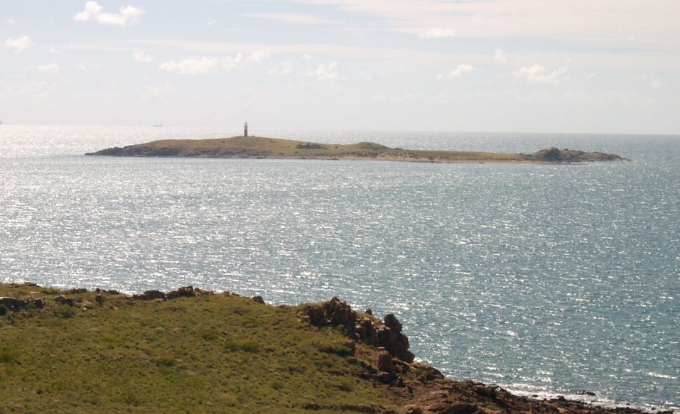
| Old lighthouse 2klm offshore near Cossack |
 |
Restored old Courthouse building in Cossack
|
 |
Old customs house building in Cossack
|
 |
Old Roebourne Goal building (1895 built) now used as the information centre
|
 |
This is the gas burn-off occurring when the new Woodside Gas plant was being tested near Karratha. This tower is about 4 stories high, which gives some idea of how large the flame was on the day we visited. The noise was incredible.
|
 |
This is the size of the gas pipes coming from the ocean wells to the plant. Note the cut-away layers on the outside.
|
 |
Part of the North West Shelf gas treatment plant. The large flame in the other photo is the one on the left side here.
|
 |
Two of the four liquid gas storage tanks on the older site at the North West Shelf Processing plant. The flame on the left happens when a ship is being loaded. It's like a safety valve.
|
 |
A portion of the gas plant near Karratha. This is about one third of its size.
|
 |
Red Dog statue at Dampier. The movie is based on this dog.
|
 |
Rio salt loading facilities at Dampier
|
 |
Salt pans on the Dampier-Karratha road. The inbound jet gives an idea of the size of these salt pans.
|
 |
Note the flood debris in the tree way above Des's head. The water pipe line in the background is out of flood level. The water comes from the underground aquifer nearby and is piped to Karratha.
|
 |
Green bush in the middle of the desert. This is the Millstream National Park sitting on an underground aquifer.
|
 |
Large waterhole in the Fortescue River at Millstream NP.
|
 |
The original kitchen building at
Millstream homestead. |
 |
Millstream homestead - now used as a museum and information centre.
|
 |
Part of the Chichester Range NP. This lookout is not far from Python Pool.
|
 |
See that little gadget where the wheel valve is! That sucker failed to give us a warning of trouble with the tyre, resulting in this beauty. Can't complain - this is our first drama in 20 months of travel.
|
 |
The Port Headland landmark - a very large wheelbarrow made from the back of a mine dump truck. Very clever.
|


.JPG)


.JPG)


.JPG)
.JPG)
.JPG)
.JPG)